When I take people out on a private tour, the guests always comment on the hills. But the city isn’t all hills. A rule of thumb is “Because we have 47 hills, if something is flat, it must be landfill.”
What is San Francisco didn’t used to be San Francisco. We’re a small city; 7 miles by 7 miles (give or take.) The story of San Francisco always involves land: how to use what little we have, and how to make more of it.
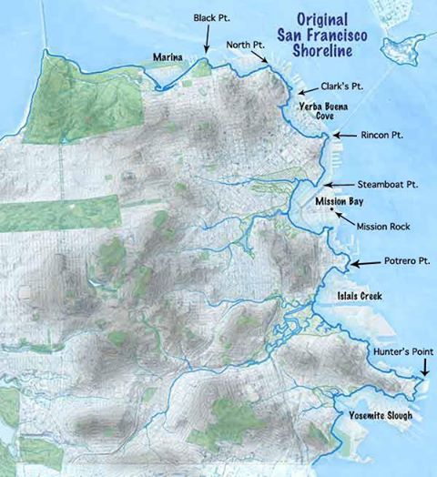
This map shows the original shoreline. Soon after the Gold Rush in 1849, Yerba Buena Cove was filled in with thousands of abandoned ships. It took an average of 5 months to get here from where ever gold seekers came from, and they came from all over the world (except Japan because it was isolated at the time) and the during the journey all they could think of was that someone was in the gold country grabbing their gold. The ships were abandoned, scrapped, and with dredging bay and dirt from the hills and became the Financial District.

The Marina lies on top of once was a fresh water lagoon. It was filled in with dredging from the bay and some debris from the 1906 Earthquake and Fire. It was filled to to be the site for the 1915 World’s Fair.
So when you walk on two of flattest parts of San Francisco, you’re walking over the 2 major events in San Francisco history.